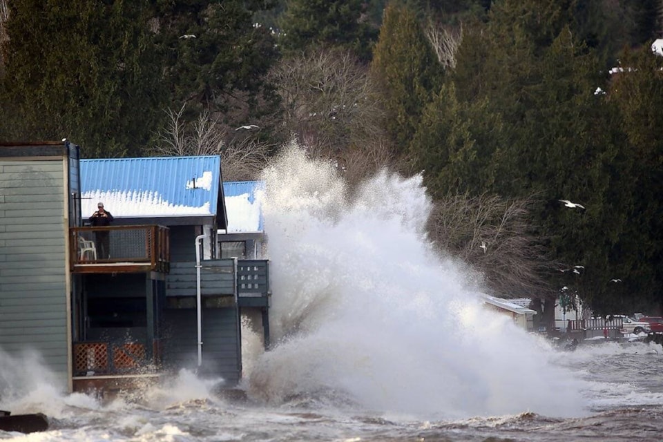
The ocean has always been part of Jan Peterson’s life — the scent of salt air, the crash of waves against the rocky shore. These were constants.
But last winter, as she stood at her picture window watching a storm surge devour the beach outside her north Nanaimo home, she felt something new — fear.
“We’ve seen big storms before, but this was different,” Peterson said. “The water was right at our doorstep. The whole coastline felt like it was breathing harder.”
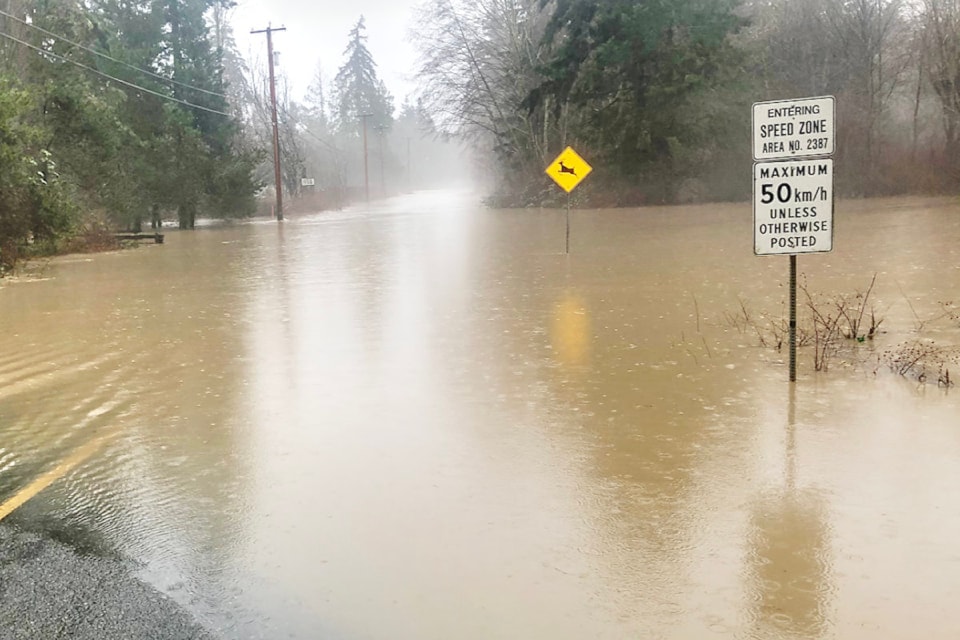
From Victoria’s Inner Harbour to Port Hardy, coastal communities on Vancouver Island are confronting the accelerating impacts of climate change. Rising sea levels, more intense storms, and eroding shorelines are no longer distant threats — they’re happening now.
Scientists warn that by 2050, some coastal areas could be permanently underwater.
Thomas James, a research scientist with the Geological Survey of Canada and an adjunct professor at the University of Victoria, says that while projections have improved slightly in recent years, sea levels are still rising — and faster than many realize.
“We’re seeing higher numbers than we did 15 or 20 years ago, though not as severe as initially feared,” James said. “Still, the trajectory hasn’t changed. The sea is rising.”
James leads a national team developing sea-level rise guidelines for federal and provincial governments. While progress is evident at all levels — municipal, provincial, and national — more action is urgently needed.
“The Paris Accord set a goal of limiting global warming to below 3 C by 2100. New forecasts are slightly better, around 2.5 C, but that still puts enormous pressure on coastal communities,” he said.
Indigenous Leadership
Coastal First Nations are among the most affected by rising seas — and also among the most proactive in preparing for them.
On eastern Vancouver Island, the Snuneymuxw First Nation is that includes restoring degraded shoreline areas and using traditional ecological knowledge to reinforce natural flood barriers.
Further north, Kwakwaka’wakw communities near Alert Bay are mapping flood-prone zones and advocating for provincial and federal support to relocate critical infrastructure.
Despite this leadership, many Indigenous communities face significant barriers — limited funding, jurisdictional overlap, and aging infrastructure ill-equipped for climate resilience.
A 2021 report from the called for co-governance in adaptation planning. It stressed that any long-term strategy for B.C.’s coasts must be grounded in Indigenous rights, land stewardship, and community-based solutions.
“True resilience means respecting Indigenous authority over their territories,” said Kees Lokman of the UBC Coastal Adaptation Lab. “The most effective coastal adaptation is being led from the front lines — and many of those are Indigenous.”
Infrastructure at Risk
Lokman notes that sea-level rise is already affecting vital infrastructure, coastal ecosystems, and community livelihoods.
According to the Capital Regional District, Oak Bay faces the highest sea-level rise risk on Vancouver Island. With more than 20 kilometres of shoreline and much of it just one to five metres above sea level, the community sits on the climate crisis front line.
A 2015 study, , estimated that by 2100, storm surges could threaten $330 million in land and buildings in the Windsor Park area alone. Sea levels are projected to rise by half a metre by 2050, increasing both the frequency and severity of flooding. By century’s end, the ocean could rise as much as 1.3 metres — enough to submerge entire neighbourhoods.
Other high-risk communities include Courtenay, Campbell River, Parksville, Sidney, Qualicum Beach, North Saanich, and Victoria’s Inner Harbour.
While Oak Bay has raised flood construction levels and supported regional studies, major coastal defences remain unfunded and unbuilt.
Funding Gaps Persist
Some Island municipalities have begun to adapt. Sidney has reinforced parts of its seawall. Courtenay is investing in natural flood defences like wetland restoration. Parksville has updated its floodplain maps to guide safer development.
Many communities have completed sea-level rise mapping and risk assessments. Several have updated their official community plans and zoning bylaws to reflect the new climate reality.
Regional agencies, such as the Capital and Cowichan Valley regional districts, are helping smaller municipalities coordinate planning and access funding.
Still, critical gaps remain. Developers continue to obtain variances that allow construction in high-risk areas. Most flood-related regulations apply only to new developments, leaving older homes and infrastructure dangerously exposed.
Across the Island, essential assets — roads, sewage treatment plants, and power lines — remain vulnerable. Victoria has started upgrading stormwater systems in Ross Bay and Rock Bay, but retrofitting entire networks is slow and costly. In Courtenay, recommended dike improvements are stalled due to lack of funding.
Insurance Pressures Rise
Residents in flood-prone zones are already experiencing financial stress.
Property values in some coastal areas have stagnated. Insurance premiums are rising. In some cases, companies have stopped offering flood coverage altogether.
In 2022 and 2023, Canada saw back-to-back years with over $3 billion in insured damages, much of it from flooding. Insurers are passing these costs on to homeowners. In B.C., home insurance rates rose 7–8 per cent in 2023 — well above inflation.
“We don’t have a strong understanding of flood risk here in B.C.,” Aaron Sutherland, VP for the Western and Pacific regions of the , told Black Press last year. He urged the government to prioritize updated flood mapping as a foundation for risk management.
The B.C. government’s new flood strategy aims to improve mapping and planning — steps that Island communities hope will support dike construction and other defences.
Nationally, there is growing support for a federal flood insurance program to protect homeowners in extreme-risk areas who can no longer find affordable private coverage.
Is the Island Ready?
Vancouver Island is already experiencing the effects of sea-level rise. Floods are more frequent, cliffs are eroding, and storms now topple trees and flood basements within minutes.
While many local governments acknowledge the risk, preparedness remains uneven. Most infrastructure — roads, wastewater systems, power lines — wasn’t built for today’s climate extremes.
The has called for a coordinated, Island-wide strategy. Its recommendations include updating building codes, raising minimum construction elevations, and expanding nature-based defences such as marshes and rain gardens. It also emphasizes inter-municipal collaboration to prevent fragmented responses.
Retrofitting aging infrastructure remains one of the biggest challenges. New policies often apply only to future developments, leaving older neighbourhoods unprotected. In underprepared areas, homeowners face rising premiums — or no insurance options at all.
James of the says that while B.C. is taking action at every level, the scale of the challenge requires more urgency.
“We’ve seen a lot of positive momentum, but we’re not where we need to be,” he said. “The sea doesn’t care about jurisdictional boundaries. We need coordinated planning, strong science-based guidelines, and faster implementation.”
'We’re Not Moving'
Back in Nanaimo, Jan Peterson says she’s staying put — for now.
“We can’t just stand here and let the water take us,” she said. “We need the province, the feds — everybody — to step up. This is our home, and we’re not moving. Not yet.”
— With files from Black Press


